


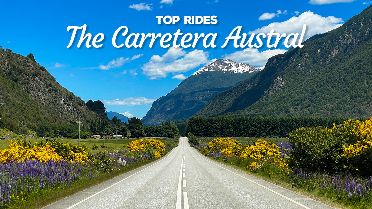
TOP RIDES: The Carretera Austral, Chile
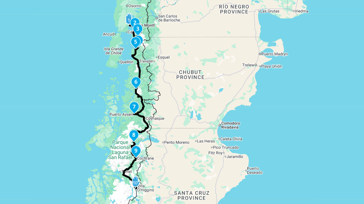
The Carretera Austral (Ruta 7) is one of the world’s great roads and should be high up on any adventure rider’s bucket list. Literally the “Southern Road”, this thoroughfare snakes its way southward from Puerto Montt in Chile through over 1,200kms of dramatic Patagonian landscape to the remote town of Villa O'Higgins.
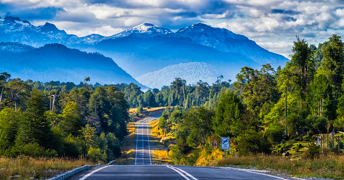
Carved through some of the southern hemisphere’s least hospitable terrain by a literal army of conscripts, construction started in 1976, with the most recent stretch only being completed in 2000. Today, travellers are treated to a never-ending parade of forests, fjords, glaciers, and wilderness, interspersed by a handful of pretty towns. Around half of the road is now paved, but plenty of adventure still remains, particularly on the southern sections.
To do the whole route, including the return from the dead-end at Villa O’Higgins, you should allow at least a full week (probably slightly more). The paved sections of the route are mostly new and in excellent condition. None of the gravel sections are particularly gnarly, but expect some steep hairpins and fairly loose surfaces. 50/50 or offroad-biased tyres are highly recommended for these sections.
Route Details
Distance: 1240km
Surface: Paved and Gravel
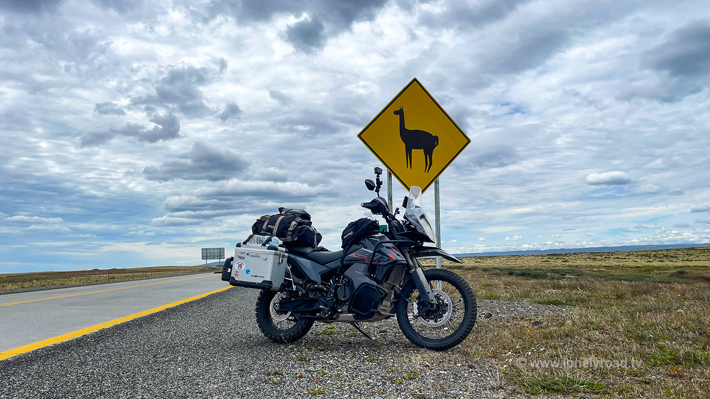
Fuel: Puerto Montt, Chaitén, Puyuhuapi, Puerto Aysén, Coyhaique, Villa Cerro Castillo, Cochrane, Villa O’Higgins
Ridden: December 2023
1. Puerto Montt to Hornopirén - 106km
The route starts in the regional capital, Puerto Montt. This modest, if slightly forgettable city is a perfectly decent staging post for an assault on the Austral. With a population circa 250,000 it has all the services you’ll need ahead of the trip, including the super-friendly team at Austral MotoSport (KTM, Yamaha, Suzuki, Kawasaki, Royal Enfield).
Officially, Ruta 7 starts at the junction of Avenida Salvador Allende and Diego Portales on the Puerto Montt foreshore. The first stage then snakes east around the edge of the Seno de Reloncaví (Reloncaví Sound) to the boat ramp at La Arena and the first ferry of the route. Ferries run 24 hours, with sailings roughly every 45 minutes at regular times and less frequently in the wee hours. The crossing from La Arena to Caleta Puelche takes around 30 minutes, and at the time of writing, the fare was $8,000 CLP one-way for a motorcycle, including rider(s). Booking isn’t possible – it’s first come, first served. Tickets can either be purchased onboard or in advance via the Transportes del Estuario website (in Spanish only). Sailing schedules are also available there.
From Puelche, the road swings inland for a bit, with some quality pavement carving its way through a combination of bushland and modest hills, interspersed by the occasional farm. There’s not much to see off the route, but the waterside hamlet of Puerto Pichicolo makes a great lunch or snack stop courtesy of the Los Reyes de las Empanadas restaurant. From there, it’s then only a short hop to the more substantial town of Hornopirén and plenty of options for accommodation.
2. Hornopirén to Chaitén - 134km
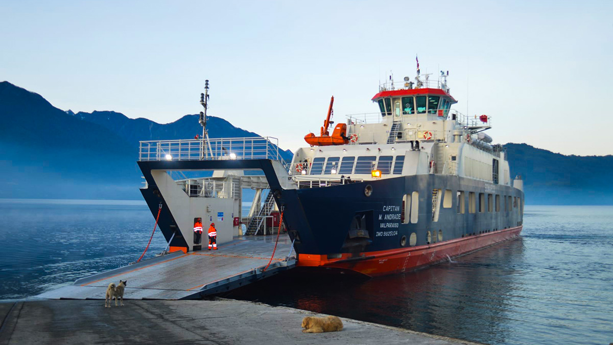
From Hornopirén it’s another ferry. This time the journey is longer – around three and a half hours to the ramp at Leptepu. The route is operated by Somarco, with two daily sailings year-round at 10:00 and 18:00, plus an additional 02:00 sailing during the summer season. The regular sailings have subsidised fares, which at the time of writing were around $17,400 CLP for a motorcycle, including rider (a pillion is an extra $11,600 CLP). On the extra summer sailing, the fare is not subsidised, so prices increase to $29,400 and $15,750 CLP respectively. Tickets must be booked in advance from the Somarco website (English and Spanish).
At Leptepu, you get off on a ramp - there’s nothing else here – and the Carretera Austral takes you to the next ferry at Fioro Largo. At 10km or so, it’s a short ride, but the road is fully-paved these days and the Austral scenery starts to tease. Your Somarco ticket from Hornopirén is also valid for this crossing and the timings are co-ordinated with your arrival at Leptepu, although it’s worth checking while you’re onboard the first leg just how much time you have to do the 10 Ks between ramps. There's no fuel or lodgings on this stretch. From Fioro Largo, the short crossing to Caleta Gonzalo takes around 40 mins. Caleta Gonzalo is also not much more than a boat ramp. But if you find yourself in need of somewhere to stay, there is the Caleta Gonzalo Lodge, which offers cabañas (cabins) for up to four people, starting at around $89,300 CLP per night, and camping pitches from $13,000 CLP per night. There’s also an onsite restaurant. Otherwise, the next accommodation (other than a couple of campsites) is in the small town of Santa Bárbara, about 45km down the road.
From Caleta Gonzalo the route is unpaved for around 35 km before the new surface kicks in and stays that way for the rest of the ride to Chaitén. On this section, the Austral really starts to deliver as you ride through a lush forest landscape ringed by snowcapped mountains. And this impressive scenery is itself overshadowed by the immense Volcán Chaitén, which erupted without warning in 2008 for the first time in over 350 years, nearly destroying the town which bears its name. If you have the time, the 2.5km hike to the volcano viewpoint is totally worth it (trailhead about 24km north of Chaitén, marked with a sign and small carpark). There are no services on this section of the route.
At Santa Bárbara, the road swings south again for the final stretch to Chaitén. The town has recovered well from the 2008 eruption, but remains a sleepy port. There are a reasonable number of accommodation and food options, as well as a COPEC petrol station. Chaitén is also the port for ferries from Chiloé and Puerto Montt.
3. Chaitén to Coyhaique - 421km
Leaving Chaiten, a beautifully paved road sweeps you southeast through the mountains which runs along the border of the Parque Nacional Pumalín Douglas Tompkins. It’s then almost due south for a stretch through a section of forest and farmland to the tiny enclave of Puerto Cárdenas at the top of Lago Yelcho, before skirting the edge of the Parque Nacional Corcovado for more mountains, rivers, and forests. The small town of Puyuhuapi sits at the northernmost point of the fjord which bears its name and is a good option for an end of day stop. There are a decent number of places to stay and it’s also a good base for hikes into the stunning Parque Nacional Queulat, including to the famous Ventisquero Colgante (Hanging Glacier). Most of the route is paved, although there are some sections of gravel where roadworks are waiting to be completed.
South of Puyuhuapi the road hugs the eastern shore of the fjord for a bit before turning inland to trace the perimeter of the Parque Nacional Queulat. The road surface alternates between paved and gravel, the latter mostly in areas where it is awaiting completion of works to add the final layer. This is until you approach a section known as the Cuesta Queulat - a taste of the Austral of old where the road narrows, snaking up 600 vertical meters through 15 gravel hairpins to the summit. It’s not too hard, but does require a bit of concentration. However, at the top you’re rewarded with brand new pavement which pretty much takes you all the way to Coyhaique.
South of the Cuesta Queulat, it’s a pleasant ride of mountains, waterfalls, lakes, and forest, past the Reserva Nacional Lago Las Torres and the Reserva Nacional Mañihuales. As you arrive at the latter (not long after the town of Villa Mañihuales), the road forks and you have a choice: stay on the Carretera Austral (Ruta 7) for 50kms of gravel or branch off onto the X-50 / 240 route for a 65km detour on pavement. The latter option is generally the better one – the views are nicer, the mountains grander, and another 18km down the 240 will get you to Puerto Aysén, one of the larger towns in the region and a pleasant stop.
From Puerto Aysén, a little backtracking is required on the 240 as it cuts through some spectacular scenery courtesy of the Reserva Nacional Rio Simpson before merging with Ruta 7 after about 55kms - it’s paved all the way. Only another 10kms or so down the road, you’ll arrive in Coyhaique, the unofficial capital of the region and largest town on the Austral. Pretty much all the services you’ll need can be found here.
4. Coyhaique to Cochrane - 329km
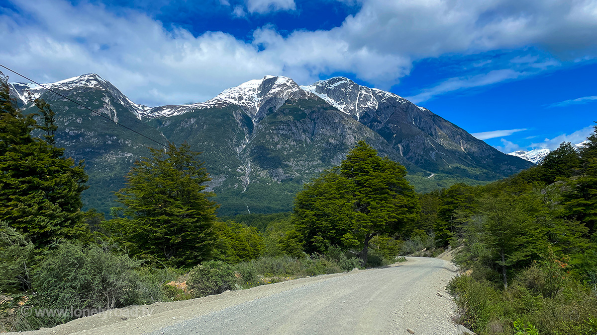
Heading south out of Coyhaique, the Austral tracks a plateau for a little bit, as you cruise through a vast valley peppered with farms and small settlements. The first photo op arrives around 13km south of town by way of a pretty waterfall running under a bridge, simply named El Salto (“the waterfall”). Beyond, the road continues southeast towards the Argentinian border before veering off to the right about 5km out of the town of El Blanco. This is where things start to get interesting as you begin the climb into the Parque Nacional Cerro Castillo. Snow-capped mountains, crystal clear rivers, and all-round stunning landscape is the order of the day. On the other side, a series of hairpins known as the Cuesta del Diablo drop you down into the next valley, with a roadside mirador (viewpoint) to admire the imposing Cordillera Castillo mountain in the distance. At 2,675 meters, it’s on the small side for this part of the world, but what makes it more impressive is its unusual prominence – height from the surrounding landscape – which at 2,088m gives it grandeur that other taller mountains can fail to achieve.
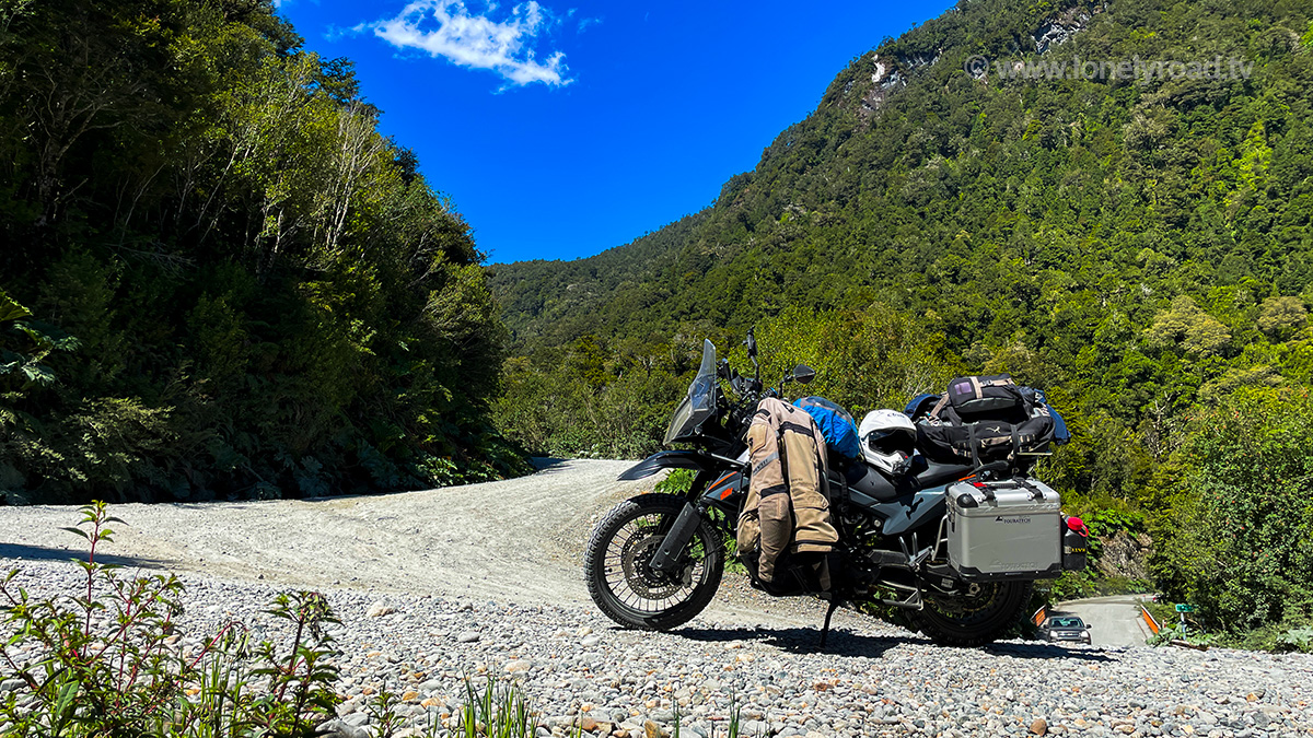
From here the route briefly crosses the valley of the Rio Ibañez at the small town of Villa Cerro Castillo, before climbing again on the other side to track the southern valley rim. The views back across the valley to the Parque Nacional Cerro Castillo mountains are worthy of a photo stop. Not long after (and about 15km from Villa Cero Castillo), the pavement ends as you arrive at the views over the Lago Verde. From here, it’s pretty much all gravel from now on. It’s clear the intention is for the paving to be continued at some point, as the gravel is largely well-groomed, if not a little bumpy here and there. But the main issue, as with much of this part of the Austral is the piles of gravel created by four-wheeled vehicles alongside their tracks. On a bike, care needs to be taken not to accidentally drift into these piles or cross without intending to. Dust is also another consideration if the conditions have been dry for some time. But the effort is rewarded with more stunning landscape and a rendezvous with the Carretera of old.
Skirting the northern reaches of Parque Nacional Laguna San Rafael, you eventually arrive at the tip of a fjord comprising part of Lago General Carrera, one of the largest lakes in this part of South America. The lakeside vistas will keep you occupied for a while until you arrive in Puerto Rio Tranquilo, the next significant town on the route. It’s pretty small overall, but boasts a reasonable number of accommodation options and also has a COPEC petrol station. The town’s main claim to fame is as a base for tours to the nearby Capillas de Marmol (marble caves). These are only accessible by boat and there are plenty of operators in town ready to take you.
South of Puerto Rio Tranquilo, the route follows the lakeshore for a while, often at height, which makes for some great views. The impressive Puente General Carrera (General Carrera Bridge) marks the entry to the Tres Lagos area and more great views. At the small settlement of Puerto Bertrand the road hooks up with the Rio Baker and shadows it along the rim of an impressive gorge pretty much all the way to Cochrane. Puerto Bertrand has a few accommodation options, but otherwise there is nothing until you reach Cochrane.
Your arrival at the latter is heralded about 4km out by the start of a small, but welcome bit of brand new paving. There are plenty of accommodation options, although most aren’t as cheap as you’d like, as well as food and fuel. Cochrane is the last town on the route before Villa O’Higgins, so is a good place to stock up for the final and most remote leg of the Austral.
5. Cochrane to Villa O’Higgins - 231km
Continuing south from Cochrane comes with a brief respite from the gravel, albeit only a measly 7km or so. But that’s ok because this last leg is as close to the Austral experience of old as you can get these days. The road surface is generally well-groomed and doesn’t suffer from much in the way of corrugations, but piles of loose gravel along the tyre tracks can catch you unawares here. The road is mostly wide enough for two cars, but there are occasional short single-track sections in some places where it hugs the hilly side of a lake or river.
The first hundred or so kilometres of this section carves a path through a series of valleys, making for a fairly flat ride. Just after the tiny, blink and you’ll miss it hamlet of Puerto Alegre, the road forks. The X-904 secondary route heads west for about 23km to the curious town of Tortel, famed for its network of wooden walkways in place of streets. It’s still a small place, but it does have a steady tourist trade so there are a few hotels and restaurants. And a visit will entail leaving your bike parked near the town entrance as most of the walkways are pedestrian only.
From the fork, the Carretera Austral itself continues another 20km up and over a small mountain range before dropping you back down at the tiny settlement of Puerto Yungay. From here, there’s one more ferry to get you across the Mitchell fjord and the final hundred kilometres or so to Villa O’Higgins. The crossing takes around 45 minutes, with four sailings per day during peak season (10:00, 12:00, 16:00, 18:00) and two in the off months. This ferry is fully subsidised by the Chilean government, so is free to ride, even with a vehicle. You can’t book – it’s all on a first-come, first-served basis – and as the ferries themselves are quite small, it’s a good idea to arrive with plenty of time to ensure you get on. You should also make sure you’re on the correct ferry (to Rio Bravo), as other services also leave from this ramp.
On the other side, you’re dropped off at the Rio Bravo ramp. There’s nothing here and your next brush with civilisation won’t come until you arrive in Villa O’Higgins. From Rio Bravo, it’s just under 100km on a rougher gravel road than you’ve experienced so far. But the consolation prize comes in the form of stunning views, lakes, roadside waterfalls, and experiencing by far the wildest part of the whole route. You’ll know you’re on the home straight when the road takes a sharp left while hugging Lago Cisnes. From there, you cross the Rio Mayer (bridge) and before long the forest will give way to a taste of civilisation.
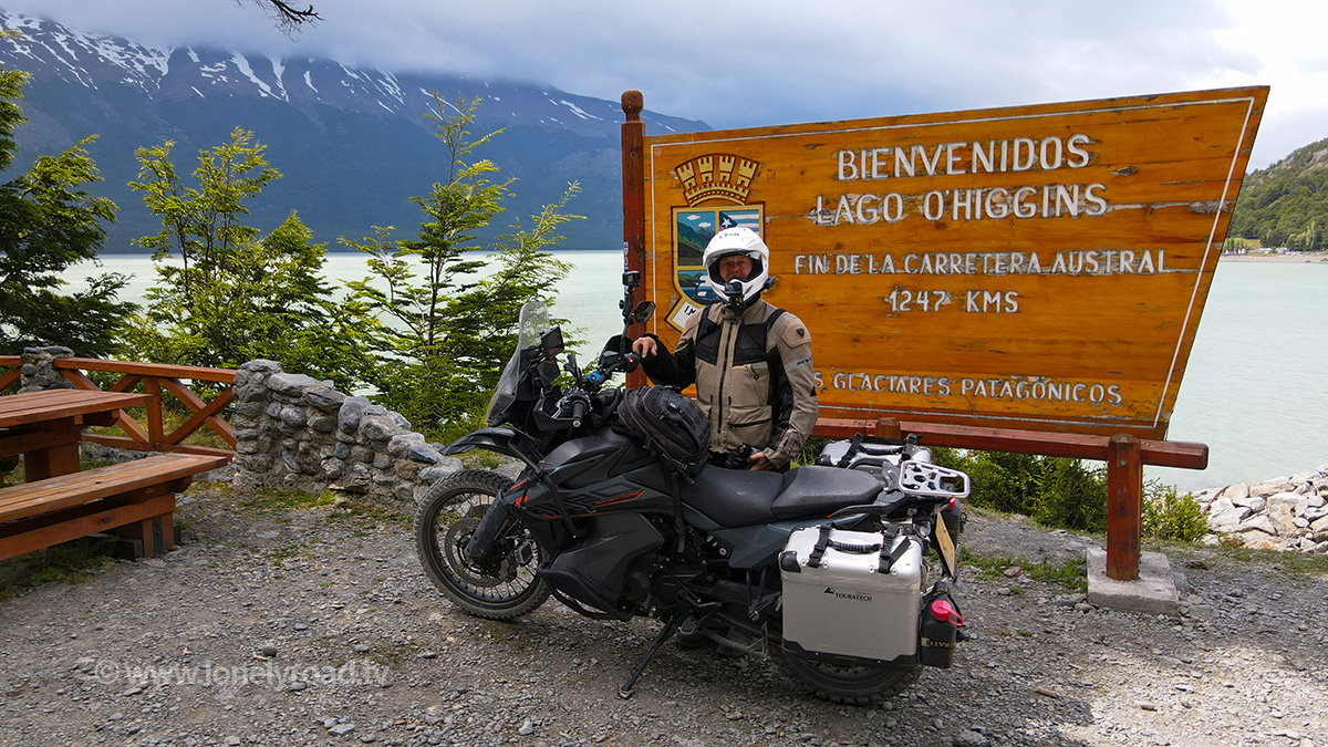
Villa O’Higgins is a small, but pleasant town, albeit a fairly quiet one. Although it’s the last stop on the Carretera Austral, it’s founding in the 1960s predates the arrival of the road (owing its existence more to asserting Chile’s territorial integrity than anything else). There are several accommodation options here, including the excellent hotel/restaurant Posada Paso Mayer, and basic services including a COPEC petrol station. It’s a pleasant place to stop.
Although Villa O'Higgins is the last town, the Carretera Austral officially ends around 7.5km down the road on the banks of Lago San Martin. Having come this far, it’s worth doing these last few kilometres, if not for the views then for the requisite selfies with the official end of the road sign. And that’s it – you’ve done the Carretera Austral.
From here your only choice is backtracking to Cochrane. Bicycles and foot travellers have a couple of options to continue across the border to Argentina (via either Paso Mayer or Paso Dos Lagunas), but neither of these is suitable for vehicles. It’s about 230km back, but a second helping of the Carretera Austral isn’t the worst thing in the world.
Route Map & GPX
Waypoints: Download GPX